http://antarvasnavideos.pro sex videos kinky babe fisting her large pussy. https://bigboobslovers.net/ hungry mom loves throat fucking.
18 April 2024
18 April 2024
Categories
After five years of intense activities carried out within the HARMONIOUS COST Action, the book “Unmanned Aerial Systems for Monitoring Soil, Vegetation, and Riverine Environments” is […]
20 December 2020
20 December 2020
Categories
With the increasing role that unmanned aerial systems (UAS) are playing in data collection for environmental studies, two key challenges relate to harmonizing and providing standardized […]
19 August 2020
19 August 2020
Categories
Some useful recommendations for UAS-surveys aimed at the derivation of 3D surface models can be found in our recent manuscript published on Drones MDPI. The results […]
18 August 2020
18 August 2020
Categories
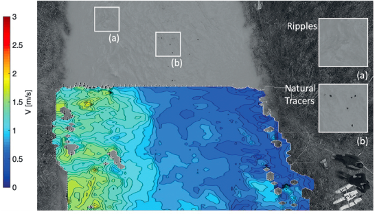
Since the turn of the 21st Century, image based velocimetry techniques have become an increasingly popular approach for determining open-channel flow in a range of hydrological […]
1 August 2020
1 August 2020
Categories
Our review manuscript "On the Use of Unmanned Aerial Systems for Environmental Monitoring" has been just published on MDPI Remote Sensing
9 January 2020
9 January 2020
Categories
Image velocimetry has proven to be a promising technique for monitoring river flows using remotely operated platforms such as Unmanned Aerial Systems (UAS). However, the application […]
27 October 2019
27 October 2019
Categories
Traditional monitoring approaches are unlikely to provide the level of detail required to advance our understanding and description of the underlying physical processes and mechanisms for […]
20 August 2019
20 August 2019
Categories
Several methods have been developed to map soil water content exploiting data in the short and long wave regions of the electromagnetic spectrum. Among these, thermal […]
7 March 2019
7 March 2019
Categories
Data, and its timely delivery, presents one of the major constraints in advancing the hydrological sciences. Traditional monitoring techniques are time consuming, expensive, and discontinuous in […]
website
big black teen apparel theft.http://desivideos4k.com/ cassandra nix and eva karera threesome.


